 Indian Rupee
 Pound Sterling
 UAE Dirham
 US Dollar
 Algerian Dinar
 Angolan Kwanza
 Argentine Pesos
 Armenian Dram
 Aruban Florin
 Australian Dollar
 Azerbaijani Manat
 Bahraini Dinar
 Baht
Baht Balboa
 Bangladeshi Taka
 Belarusian Rubles
 Belize Dollars
 Bermuda Dollars
 Bhutanese ngultrum
 Bolivares Fuertes
 Brazilian Reais
 Bulgarian Leva
 Burundian Franc
 Cambodian Riels
 Canadian Dollar
 Central African CFA franc
 Chilean Pesos
 Colombian Pesos
 Colón
Colón Congolese Franc
 Cuban Pesos
 Danish Krone
 Denars
 Djiboutian Franc
 Dominican Pesos
 Dong
Dong East Caribbean Dollars
 Egyptian Pounds
 Ethiopian Birr
 Euro
Euro Forint
 Georgian Lari
 Ghanaian Cedi
 Guarani
 Guinean Franc
 Guyanese Dollars
 Hong Kong Dollars
 Hryvnia
 Icelandic Krona
 Indonesian Rupiahs
 Iranian Rials
 Jordanian Dinar
 Kenyan Shilling
 Kips
Kips Koruny
 Krone
Krone Kuna
Kuna Lati
Lati Lebanese Pounds
 Libyan Dinar
 Lira
Lira Litai
Litai Malagasy Ariary
 Malawian Kwacha
 Malaysian Ringgit
 Maldivian Rufiyaa
 Mexican Pesos
 Moldovan Leu
 Moroccan Dirham
 Myanmar Kyat
 Nairas
 Namibian Dollars
 Nepali Rupee
 New Dollars
 New Lei
 New Shekels
 New Zealand Dollars
 Nuevos Soles
 Omani Rial
 Pakistani Rupees
 Papua New Guinean Kina
 Philippine peso
 Pula
Pula Qatari Rials
 Quetzales
 Rand
Rand Russian Rubles
 Rwandan Franc
 Saudi Riyals
 Singapore Dollars
 Soms
Soms South Korean Won
 St. Helena Pounds
 Sudanese pound
 Sums
Sums Swedish Krona
 Switzerland Francs
 Syrian Pounds
 Tajikistani Somoni
 Tanzanian Shilling
 Tenge
Tenge Tugriks
 Tunisian Dinar
 Ugandan Shilling
 Uruguayo Pesos
 West African CFA franc
 Yemeni Rials
 Yen
Yen Zambian Kwacha
 Zlotych
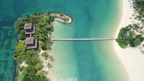
During a half-century of independence, Singapore fought to expand its territory inch by inch.
On the trip to the peninsula of Malaysia, the island city piled up sand to expand its coastline and reclaim land from the sea. In that time, Singapore grew by one quarter, adding a landmass over two times the size of Manhattan, and it plans to increase by an additional 4 % by 2030. It is a significant accomplishment, said that many coasts are receding due to rising sea levels and climate change. "We are not planning to lose any inch of land permanently," says Ho Chai Teck, a deputy director at PUB, the government agency coordinating the effort to save the nation's shores, "Singapore will build a continuous line of defence along our entire coast. This is something that we take very seriously." Roughly one-third of Singapore is less than 16 feet above sea level, low enough for flooding to cause punishing financial losses. Some of its most prized property sites on vulnerable land are the skyscrapers overlooking the Marina Bay waterfront known for its luxury mall and casino and the towers that house giant banks like the Singapore-based DBD Group Holdings Ltd Southeast Asia's most significant and UK-based Standard Chartered Plc.
Assuming 1.5 C of warming, prime real estate in the city worth S$70 billion faces the risk of flooding as per Bloomberg estimates with the help of data from real estate company CBRE Group Inc. Jurong Island is another endangered and vital part of the country, where Shell Plc and Exxon Mobil Corp have oil and petrochemical operations. "You have got small nations, but they do not have this much economic wealth," says Benjamin Horton, a professor at Nanyang Technological University in Singapore who studies sea level change. "The actual value of every square meter in Singapore is off the charts. This country is more susceptible to rising sea levels than any other country." In 2019, Prime Minister Lee Hsien Loong said that Singapore would need to spend S$100 billion over the next 100 years to protect against rising sea levels. The government has since put S$5 billion toward a coastal and flood protection fund. "Both the Singapore Armed Forces and climate change defences are existential," he said. "These are life and death matters. Everything else must bend at the knee to safeguard the existence of our island nation." A day's bike ride along Singapore's coastal paths will take you past glittering skyscrapers and scenic dams, beaches and mangrove swamps, diverse scenes that make clear how the country must carefully tailor its approach. Other populous coastal cities include Bangkok, Miami, New York and Shanghai.
Fortifying the city
On a recent weekday, tourists and locals fly kites on a towering structure with dazzling views of Singapore's skyline. But what they are standing on is much more than an attraction. It is an SS226 million dam called the Marina Barrage. Some of the seven giant pumps drain water in the sea during high tide and extreme rainfall. Some kind of artificial barrier protects 70% of Singapore's coastline. However, the city-state must reinforce and improve the shields as tropical storms enhance and sea levels rise.
The Hydroinformatics Institute and the National University of Singapore are working with PUB to build a complete model stimulating the combined effects of sea level rise and rainfall on the country's coastlines; when finished in 2025, it will help assess which areas are most vulnerable based on the predicted depth and duration of floods. "We have to look at this in a very dynamic way," Grace Fu, minister for sustainability and the environment, said at a September event launching a new coast and flood protection institute. "Protecting us too much, you waste a lot of resources. If you build the coat protection solution too low, you must enhance it several generations later.
Government bodies are already considering storm surge barriers on Singapore's waterways. The barriers would usually be open so ships could travel to their destinations, but during a big storm, they would close, encircling the city's industrial areas. Other possible measures are raising the height of coastal reservoir dikes, establishing tide gates that block water, and constructing more embankments, usually raised piles on earth. Singapore is also building a substantial additional terminal at its airport on higher ground 18 feet above average sea level. More than 6 miles of drainage are planned to keep runways clear of the water. Businesses are getting into the act, too. City Developments Ltd has built barriers and water level sensors at the St. Regis Singapore Hotel, Palais Renaissance shopping mall and Republic Plaza skyscraper. In the business district, Frasers Property's 38-story tower has added floodgates. "More still needs to be done says David Fogarty, CBRE's head of ESG consulting services for Singapore and Southeast Asia. "Companies are thinking about rising sea levels but are not acting fast enough."
Enlisting Nature
At the Sungei Buloh Wetland Reserve, the roots of mangrove trees have all kinds of configurations. They can look like pencils or bent knees of a stilt. The tropical trees flourish in slaty tidal waters; their thick above-ground break waves and trap sediment, forming a natural barrier to rising seas. To adequately protect shorelines, mangrove forests should sprawl for hundreds of yards. In neighbouring Indoensia, they can even move for miles. In Singapore, mangroves can reduce storm wave heights by 75%; mangrove forests also soak up to four times as much carbon as rainforests.
But mangroves alone are not enough. Singapore is studying whether it can mix the trees with other barriers called revetments, usually made of stone or concrete. Experiments involving combined mangrove rock revetments are underway at Kranji Coastal Nature Park near the wetland reserved and Pulau Hantu, an island off the southern coast. Singapore's existing sea walls and revetments limit one possible solution encouraging the growth of more mangrove habitats, says Daisuke Taira, a mangrove researcher at the National University of Singapore's Center for Natur-based Climate Solutions. Researchers say that the country should protect the current habitat of tropical trees and their protective roots. However, it would likely rely more on barriers and other engineering feats. When cultivating mangroves to keep the seas at bay, Taira says, "Singapore is one of the most challenging places."
Borrowing from the Dutch
On Pulau Tekong, an island northeast of Singapore, giant machinery whirs and clanks as workers stabilize soil and lay out a network of intricately curated drains and pumps. The equipment collects and channels rainwater into a pond. Excess can then be pumped into the ocean. This system, along with sea walls, enables Sinagproe to do something extraordinary: reclaim land that is below sea level. Singapore is taking a page from the Netherlands, a third of which is below sea level; the Dutch built sea walls beyond their coastline, creating new traits of land they call polders. A bean-shaped plot of land on Pulau Tekong is the first polder in Singapore. At 3 square miles, it will add 1 % to Singapore's landmass once completed at the end of 2024 and used for military training.
Polders use much less sand than the kind of reclamation Singapore has used in the past, which is a massive advantage because it is the world's largest importer of sand, which is costly. Singapore has adapted Dutch ways to the tropics side. Pacific corner is calmer than the North Atlantic, so sea walls do not need to be as high as in the Netherlands, as per Jan Jaap Brinkman, a director at the Dutch water research institute Deltares who has advised Singapore. Yet, it has more rain, so its ponds, canals, and pumps are curated to cope with more water. Brinkman says that the government is slowly learning and starting relatively small on Pulau Tekong: "Singapore wants to see if the technology is safe and ensure everything is working well before it takes the next step."
#singaporenews #singaporeupdate #singaporeislands #climatechange #globalwarming #territory